
Point Cloud: How Millions of Points Become an Accurate Digital Model of a Real-World Asset
Imagine an engineer receives drawings of a building scheduled for renovation. The plans look logical, but a site visit reveals a shifted wall, replaced equipment, and services above the ceiling that the documentation does not show. The team must decide what to trust: the old file or the conditions on site.
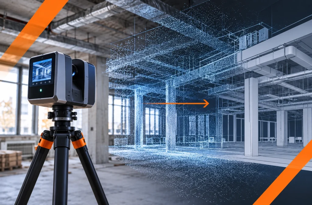
This is where Point Cloud technology comes in. Laser scanning and other reality capture methods record the spatial position of many points on an object’s surfaces. The team can then use this digital record to inspect, measure, and model existing conditions.
It may look like magic: millions of points gradually reveal a recognizable space — a façade, room, road, or industrial site. In reality, the result depends on measurements, mathematical processing, engineering checks, and decisions that software alone cannot make.
What Is a Point Cloud?
A Point Cloud is a set of spatial coordinates, usually X, Y, and Z, captured through scanning or another reality capture method. Depending on the equipment and workflow, each point may also contain color, return intensity, and other information.
Think of a photograph, but instead of flat pixels, it contains measured points in 3D space. When the dataset is dense enough and correctly aligned, engineers can inspect object shapes from different angles, analyze geometry, and prepare data for further work.
However, a Point Cloud is not a BIM model. A scanner does not understand that a surface represents a “wall” or a “beam” as an information-model object. It records surface measurements. Turning that data into intelligent model elements requires interpretation, classification, and modeling.
How a Real Object Becomes a Digital Model
Step 1. Define the scanning objective
Before setting up the equipment, decide what the data must support. A façade project needs different coverage and tolerances from an industrial renovation or a road corridor project.
The objective determines scan density, required accuracy, scanner positions, control points, and the final delivery format. Without a clear brief, a team can produce a huge file that does not contain the information designers actually need.
Client tip: Do not simply request “a building scan.” Agree on areas of interest, coordinate system, expected accuracy, data format, and processing requirements with the service provider.
Step 2. Capture the data
A terrestrial laser scanner, mobile system, or another reality capture tool measures the object’s geometry. Complex spaces often require scans from several positions. One scanner position cannot capture areas hidden behind a column, piece of equipment, or wall.
This is similar to a site inspection: when an important part of a structure is blocked, the surveyor needs another viewpoint. A large dataset cannot compensate for blind spots.
Step 3. Register and combine scans
Specialists align individual scans in one coordinate system. This process is called registration. Depending on the equipment, it may use overlapping geometry, targets, control measurements, and other methods.
Autodesk ReCap Pro provides tools to register scans and create a unified Point Cloud. Even when the software reports a successful alignment, a specialist must review residual errors and confirm that the result meets project requirements.
If two parts of a site do not align accurately, the error may be hard to notice in an overall view. It can still affect measurements and the BIM model later.
Step 4. Clean, classify, and prepare the data
A site scan captures more than the required structures. It may include people, vehicles, vegetation, temporary objects, glass reflections, noise, and areas with insufficient coverage.
At this stage, the team removes unwanted data, selects relevant areas, checks coordinates, and prepares the dataset for the target software. Road projects require careful identification of ground points. Building projects require teams to distinguish permanent structures from temporary objects.
A poorly prepared Point Cloud can look detailed but provide an unreliable basis for further work. Data preparation can matter more than the impressive file size.
Step 5. Model the asset: Scan-to-BIM or Scan-to-CAD
The next step depends on the client’s required deliverable. Sometimes the registered Point Cloud is enough to review existing conditions. Other projects need 2D drawings, 3D geometry, a terrain surface, or a BIM model.
In Scan-to-BIM, specialists interpret the data and model relevant elements such as walls, slabs, beams, and building systems. In Scan-to-CAD, the output may be drawings or other geometric documentation. ReCap Pro also offers workflows for converting point clouds into meshes. A mesh is a geometric surface, not automatically a complete BIM model.
There is an important professional boundary: if the scan does not show a hidden part of a structure, engineers must not present an assumption as a measured fact. They should clearly mark uncertainty.
Where Point Clouds Deliver the Most Value
Renovation and adaptation of existing buildings
Older buildings rarely match their archived drawings perfectly. Changed openings, new partitions, removed equipment, and unusual structures create design risks. A Point Cloud records actual geometry and gives the team a more reliable basis for renovation.
Imagine an architect planning a new stair core. The old plan shows enough space. The scan reveals a structural element in that location. Finding this before approving the design is far better than discovering it during installation.
MEP: when every centimeter matters
Mechanical, HVAC, and plumbing engineers often face difficult conditions in plant rooms, existing shafts, and ceiling voids. Ducts, pipes, cable trays, beams, hangers, and equipment all compete for space. Actual site conditions can differ significantly from design assumptions.
A Point Cloud helps teams review available space and the location of visible elements. Engineers can plan system routes, assess installation constraints, and raise questions with the client. Hidden services still require other inspection methods.
Roads and infrastructure
Road designers use Point Clouds to analyze existing pavement, curbs, shoulders, slopes, and other features. After proper processing, the data can support surfaces in Civil 3D, profiles, and design decisions.
For example, a junction renovation requires accurate existing levels for pavement and tie-ins. Scanning can capture detailed geometry of visible surfaces. The engineer must still filter traffic, check control points, and confirm that the data suits the required calculations.
Façades and complex geometry
When a façade has irregularities, complex angles, or significant deviations from a flat plane, a Point Cloud helps compare the design geometry with actual site conditions. This is especially useful before fabricating or installing elements that depend on precise fit dimensions.
However, the final tolerance and inspection method must meet the requirements of the specific project and manufacturing process. Point Clouds do not replace control measurements where those measurements are required.
Why Millions of Points Do Not Always Mean an Accurate Model
A common misconception is to confuse point density with accuracy. A dense cloud may look impressive on screen but still contain systematic shifts, registration errors, distortions on complex surfaces, or too few control measurements.
Before using the data, ask at least four questions:
- What is the measurement and registration accuracy? Check the quality of the actual dataset, not only the instrument’s theoretical specifications.
- What could the scanner actually see? Hidden areas do not become reliable just because the digital model looks continuous.
- Are the coordinates and units correct? Coordinate-system errors can undermine even high-quality geometry.
- What level of detail does the project need? A general renovation model and a fabrication-ready detail may require different methods and tolerances.
The engineering value of a Point Cloud does not come from the largest possible file. It comes from data that meets the needs of a specific decision.
Common Point Cloud Workflow Mistakes
Mistake 1: Modeling everything in the scan. Not every visible object needs to become a BIM element. Define the modeling purpose and required information level first.
Mistake 2: Ignoring hidden areas. If the scan contains no data behind a piece of equipment, mark the gap and investigate it. Do not fill it with an unverified “logical” assumption.
Mistake 3: Skipping registration checks. A small shift between scan stations can affect critical dimensions.
Mistake 4: Delivering a huge file without structure. Clients need clear names, version control, coordinate information, file formats, and a list of limitations.
Mistake 5: Treating a mesh as BIM. A mesh represents a surface. It does not replace construction semantics, parameters, or model discipline.
These mistakes share one cause: the team treats the scan as a finished answer. In reality, it is a dataset for engineering analysis.
Tools Used in Point Cloud Workflows
Autodesk ReCap Pro supports scan processing and registration, Point Cloud preparation, and selected mesh workflows. Revit can use prepared data as a basis for modeling existing buildings and systems. Civil 3D supports infrastructure workflows and surface creation from appropriately prepared data. GIS adds spatial context, site analysis, and the integration of different types of geospatial information.
None of these tools replaces knowledge of surveying, coordinate systems, building structures, or project requirements. High-quality digital models emerge where these skills meet.
Why Point Clouds Matter for an Engineer’s Career
For a junior candidate, Point Cloud work is a chance to stand out through an understanding of a real workflow, not just impressive visuals. Employers want to know whether you can interpret a brief, check source data, distinguish facts from assumptions, organize files correctly, and hand work over to another specialist.
Start with a small learning task. Use a dataset that is available for permitted use, select a limited area, prepare the Point Cloud, and model several representative elements. Then add more than a screenshot to your portfolio. Explain the source data, assumptions, checks, and final result.
For international projects, learn terms such as registration, coordinate system, point cloud, scan-to-BIM, surface, deviation, accuracy, tolerance, and deliverable. Explaining data limitations in English can be just as important as creating the model.
The Future: Not a Digital Copy for Its Own Sake
Reality capture capabilities continue to expand, and data processing is becoming easier. But the key question remains: what decision can the team make with the information it captures?
An architect may use it to plan a renovation more accurately. An MEP engineer may use it to understand a pipe route. A road designer may use it to build a more reliable existing-ground surface. A client may use it to reduce uncertainty before construction starts.
That is the real strength of Point Cloud technology. It does more than show an object on a computer. It helps engineers understand the real conditions they need to work with. Millions of points matter only when they lead to a better-informed decision.
FAQ: Frequently Asked Questions About Point Clouds
It is a set of points with spatial coordinates that represents measured surfaces of a real object or area. Teams often capture this data using laser scanning or photogrammetry.
Some operations can be automated, but a complete and accurate BIM model usually requires configuration, engineering interpretation, and quality checks. Do not confuse a mesh with a parametric BIM model.
A Point Cloud consists of individual points in 3D space. A mesh connects vertices to form surface polygons. Both can describe shape, but they have different structures and use cases.
No. Consider the project objective, asset complexity, available source data, required tolerances, and survey cost. Traditional measurements may be sufficient in some cases.
Yes. After data preparation, including workflows in ReCap Pro, teams can use Point Clouds in Civil 3D for infrastructure tasks, including surface creation.
They need to understand coordinates, accuracy, and scan registration; work with Point Clouds; use Revit or another target platform; understand building structures; and document assumptions clearly.
Would you like to work with digital models of real-world assets and develop your skills in BIM, Revit, or infrastructure design? Explore engineering vacancies at join-jot.com, prepare your CV, and show in your portfolio how you turn data into a verified technical solution.